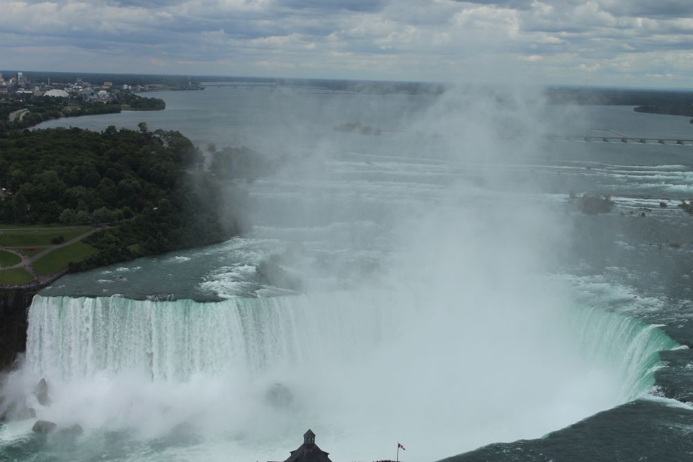
Niagara Falls on a bright day with mist rising from the gorge
Information Guide for Niagara Falls

Niagara Falls, Where Every Drop Tells a Story.

Welcome to the breathtaking Niagara Falls, where over six million cubic feet of water thunder over the crest every single minute! Make sure your ponchos are fastened tightly, because we are about to get up close and personal with the roaring mist of the spectacular Horseshoe Falls.

The Power of Nature

A landscape carved by ice, stone, and moving water

Niagara's story begins far before the modern river. Ancient seas laid down layered rocks, and the last Ice Age rearranged the Great Lakes basin. As the Wisconsin Glacier melted roughly 12,000 years ago, enormous volumes of water found a route from Lake Erie toward Lake Ontario and began cutting the Niagara Gorge.

The falls are dramatic because the rock is uneven. Hard Lockport Dolostone acts as a capstone, while softer shales below are easier for the river to undercut. As the base erodes, unsupported caprock breaks away, letting the brink retreat upstream.

Travel note: this is why the falls are not frozen in place. The view you see today is a moment in a long migration through the escarpment.
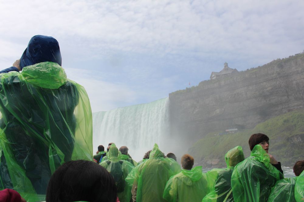
Boat tour approaching the mist at Niagara Falls
Where the gorge still grows
Lockporthard dolostone caprock
Shalesofter underlayers erode first
11 kmapproximate gorge journey
50kyears to Lake Erie, estimated without intervention
Field Notes

The engine of erosion

Over the past 12,000 years, the powerful waters of Niagara Falls have carved a deep gorge through layers of solid rock, causing the falls to gradually retreat about seven miles (11 kilometers) upstream from their original location near present-day Lewiston, New York. In the past, natural erosion caused the falls to recede by several feet each year. Today, a combination of water diversion for hydroelectric power generation, rock stabilization projects, and ongoing engineering efforts has reduced the erosion rate to only a few inches annually, helping preserve one of the world's most spectacular natural landmarks for future generations.

How the cliff renews itself

01
Water falls over the caprock. The river pours over the resistant Lockport Dolostone, creating the hard lip of the waterfall.
02
Spray and force attack the base. Turbulence erodes the softer shale and sandstone beneath the capstone, forming an undercut notch.
03
The overhang weakens. Unsupported blocks of caprock fracture, collapse, and add boulders to the base.
04
The brink shifts upstream. The same cycle repeats, preserving the drop while slowly migrating the falls toward Lake Erie.

A relentless retreat: an 11 km journey

12,000 years ago The birth

The falls formed along the edge of the Niagara Escarpment as meltwater from retreating glaciers carved the Niagara River route.

Before the 1900s Natural erosion

The original page notes a historic retreat rate of about 3 to 5 feet annually before large-scale intervention and flow control.

20th century Human intervention

Hydropower diversions reduced the amount of water flowing over the crest, slowing erosion to roughly 1 foot annually in the page's summary.

The far future 50,000 years?

Without human intervention, geologists estimate the falls could eventually erode back toward Lake Erie, altering the drainage of the lake system.

The Human Story

From sacred ground to public wonder

Niagara has been more than a view. It has been a spiritual landmark, a borderland, a battleground, a commercial spectacle, and one of North America's early conservation victories.

First Peoples and meaning

The original page traces human connection to roughly 13,000 years ago, when the falls and river landscape held spiritual significance for the first inhabitants of the region.

Conflict and settlement

European settlement in the 1600s changed the river corridor into a contested border zone, with the War of 1812 adding another layer to the landscape's story.

Conservation before it was fashionable

By the 1800s, intense tourism threatened the falls' natural character. Frederick Law Olmsted and others championed public access and protection, leading to parks in 1885 in the United States and 1888 in Canada.

Dancing on the Brink

A history of daredevils

Filter the journal cards by outcome. The original interactive page presented Niagara's daredevils as a gallery; this version keeps the sorting but gives the cards a scrapbook feel.

Taming the Giant

The river that helped teach the world to transmit power

Niagara's energy story is a mix of invention, engineering, politics, and restraint. The same water that amazes travelers also became a laboratory for modern electricity.

1896

The War of Currents

The page highlights Niagara's decisive role in the late-1800s contest between direct current and alternating current. The Edward Dean Adams Power Station used Tesla's AC system to transmit electricity about 25 miles to Buffalo, helping establish AC as the foundation of modern grids.

1950 treaty

A delicate balance

The Niagara River Water Diversion Treaty balanced scenic flow with electricity production. During some periods, large shares of the river can be diverted through tunnels and plants, while daylight scenic flows are protected for visitors.

Niagara vs. the world's titans

Niagara is not the tallest or widest waterfall, but the original page emphasizes its volume. Hover the bars to compare average annual flow rates with Victoria Falls and Iguazu Falls.

The power of the treaty

Toggle between a simplified natural-flow view and a daytime scenic-flow view. The demonstration mirrors the source page's idea: flow management makes the tourist experience and power generation coexist.

Values are a simplified visualization based on the uploaded page's demonstration numbers.

Fallsview hotel perspective of Niagara Falls
Experience the Falls

Two countries, two very different ways to meet the water

The Canadian side gives the sweeping panorama and pageantry. The American side puts you close to islands, decks, and the brink. The best trip reads both shorelines as one landscape.

Canada: panorama USA: immersion Bridge: passport needed

Canada: panorama and pageantry

Best for wide, postcard views of all three falls plus a busy entertainment district close to the rim.

Journey Behind the Falls

Descend to tunnels and a viewing deck at the base of Horseshoe Falls for a roaring, mist-filled encounter.

Skylon Tower

Ride up to a high 360-degree observation view across the falls, gorge, and surrounding region.

Clifton Hill

A lively strip of arcades, museums, themed restaurants, and the Niagara SkyWheel.

USA: immersion and nature

Best for intimate access to the brink, islands, park paths, and spray-soaked experiences.

Cave of the Winds

Walk gorge decks near Bridal Veil Falls, including the famous Hurricane Deck during the main season.

Maid of the Mist

A classic boat ride into the mist at the base of Horseshoe Falls, surrounded by thunder and spray.

Goat Island

A quieter island vantage point between the American and Horseshoe Falls, with close views of the brink.