Majestic view of Niagara Falls with mist rising over the Niagara River
Travel Journal / Geography Field Notes

A Deep Dive into Niagara Falls

Niagara is more than a famous waterfall. It is a short, powerful river corridor between two Great Lakes, a border landscape shared by Ontario and New York, a gorge carved through an escarpment, and three separate waterfalls divided by islands.

Start with the map

The geography is the reason the falls feel so powerful.

Niagara Falls sits on the Niagara River, which links Lake Erie with Lake Ontario. The river is not long, but it carries Great Lakes water across a sharp change in elevation before sending it through the Niagara Gorge.

At the brink, the flow is split by Goat Island and Luna Island into three named waterfalls: Horseshoe Falls, American Falls, and Bridal Veil Falls. Together they create the wide mist cloud, emerald water, rainbows, and roar that define the place.

Travel-blog tip: think of Niagara as a corridor, not just a viewpoint. The best trip follows the river from the calm upper reaches to the rapids, the crest, the gorge, the whirlpool, and finally the lake country downstream.
Daytime view of Horseshoe Falls and the Niagara River
Field note: follow the river
By the numbers

Fast geography facts

A quick card set for the physical setting: height, flow, river role, retreat, and border context.

>168km3 per minute over the crest at peak tourist flow
57 maverage Horseshoe Falls drop into the Lower Niagara River
7 miapproximate upstream retreat in about 12,500 years
2Great Lakes connected by the Niagara River
1international border running through the landscape
River route

How the water reaches the brink

The falls make more sense when you travel downstream in your mind. The Niagara River drains Lake Erie, gathers force in the upper river, breaks into rapids, drops over the three falls, then races through the gorge toward Lake Ontario.

01

Lake Erie outlet

The river begins near Buffalo, New York and Fort Erie, Ontario, carrying water north from Lake Erie. This makes Niagara part of the larger Great Lakes-St. Lawrence drainage system.

02

Upper Niagara River

Upstream of the falls, the river is broad and island-dotted. Around Grand Island, it splits into the Canadian or Chippawa Channel on the west and the American or Tonawanda Channel on the east.

03

Rapids before the drop

Near the crest, the surface changes from a wide river into the Cascade Rapids. The water accelerates in the final kilometer before the brink.

04

The three waterfalls

Goat Island and Luna Island divide the flow into Horseshoe Falls, American Falls, and Bridal Veil Falls. Horseshoe carries most of the river's visible tourist-season flow.

05

Lower Niagara River and gorge

After the plunge, the river is compressed into steep gorge walls, then passes the Whirlpool Rapids and Whirlpool before continuing toward Queenston-Lewiston and Lake Ontario.

Three distinct waterfalls

The falls are a natural triptych

The name "Niagara Falls" sounds singular, but the scene is split by islands into three different curtains of water.

Horseshoe Falls largest flow

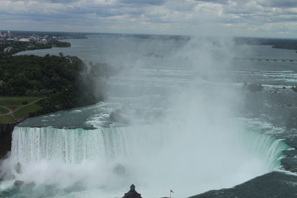
Horseshoe Falls is the great curved cataract on the Canadian side of the channel, stretching between Terrapin Point on Goat Island and Table Rock in Ontario. It drops about 57 m into the Lower Niagara River and carries the overwhelming share of the flow.

American Falls rocky base

American Falls sits fully on the U.S. side between Prospect Point and Luna Island. Its visible drop is shortened by the huge talus slope, a pile of fallen blocks that collects at the base and reveals the ongoing work of erosion.

Bridal Veil Falls smallest

Bridal Veil Falls is the narrow, delicate chute separated from American Falls by Luna Island. It is the closest waterfall to the Cave of the Winds decks, which makes it the most intimate geography lesson on the New York side.

The island split Goat and Luna

Goat Island separates Horseshoe Falls from the American and Bridal Veil falls. Luna Island then separates American Falls from Bridal Veil. These small pieces of land are the reason the river arrives as three different falls instead of one unbroken ledge.

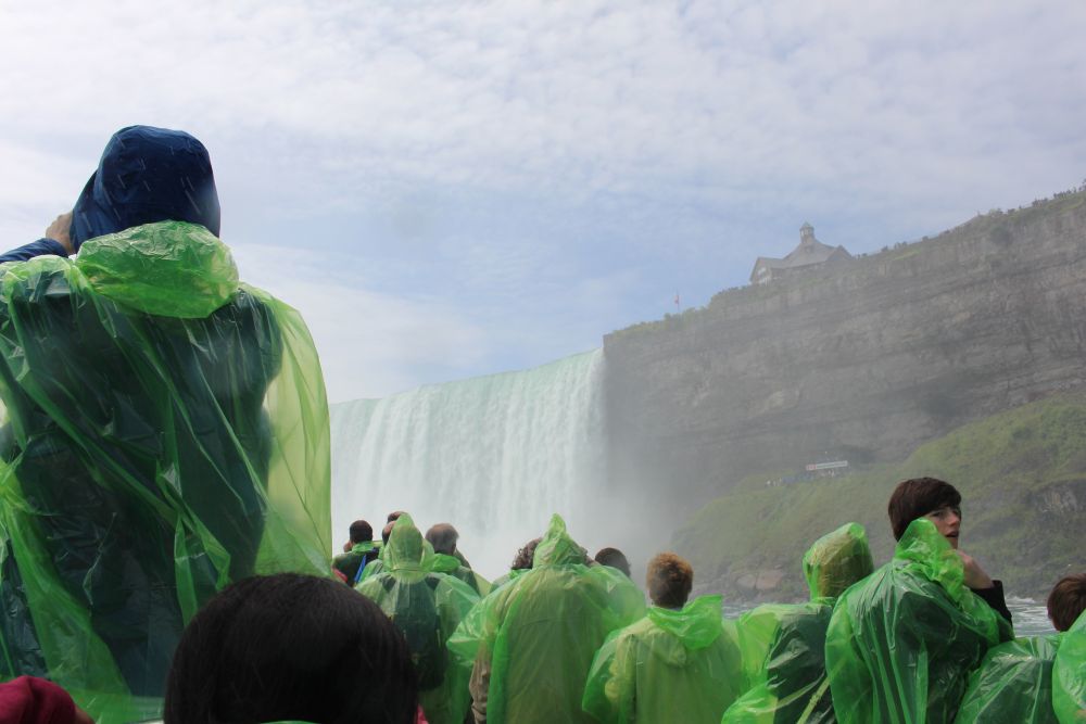
Boat tour approaching the mist and base of Niagara Falls
At the baseHorseshoe mist
Landscape anatomy

Geography details worth noticing on the ground

These are the physical features that shape what visitors see, hear, photograph, and feel.

Border river

A shared international landscape

The Niagara River forms part of the Canada-United States boundary. At the falls, the cities of Niagara Falls, Ontario and Niagara Falls, New York face each other across the gorge and river corridor.

Great Lakes

A short channel between huge lakes

The river is a connecting channel between Lake Erie and Lake Ontario. Its force comes from moving Great Lakes water across a substantial elevation drop in a relatively short distance.

Gorge

A canyon made by retreat

The Niagara Gorge is the scar left behind as the falls migrated upstream from the escarpment. The steep walls downstream are the visible record of thousands of years of erosion.

Escarpment

The cliff line that started it

The Niagara Escarpment is the hard step in the regional landscape. When post-glacial water reached this edge near Queenston-Lewiston, it began cutting backward through the rock.

Rock layers

Hard cap, softer base

Resistant limestone and dolostone layers protect the top, while softer shale and sandstone below are undercut by spray, turbulence, and collapsing water. That undercutting creates periodic rockfalls.

Emerald water

The color is geography in motion

The green color comes from dissolved minerals and very fine rock flour carried by the river. The water is literally tinted by the rocks it erodes from the limestone, shale, and sandstone layers.

Rapids

Speed before and after the brink

Above the falls, the Cascade Rapids signal the final acceleration. Below, the Whirlpool Rapids show how the river is squeezed into a narrow gorge with a steeper gradient.

Hydropower

Flow is managed, not untouched

Water is diverted for hydroelectric generation on both sides of the border. This reduces erosion and keeps a required scenic flow over the falls during tourist hours.

Viewpoints

Every overlook teaches a different map

Table Rock reveals the curve of Horseshoe Falls. Prospect Point frames American Falls. Luna Island places you between American and Bridal Veil. Terrapin Point gets closest to the Horseshoe brink.

Geology and formation

A post-Ice-Age waterfall still moving through the map

Niagara Falls is young in geologic terms. Its present landscape began after the last Ice Age, and the falls have been cutting upstream ever since.

Ice sheets carved the basin about 18,000 years ago

Southern Ontario and the Great Lakes region were covered by thick ice. Advancing and retreating ice gouged the Great Lakes basins, then released meltwater as the climate warmed.

Meltwater found one route about 12,500 years ago

As the ice retreated, water from Lake Erie flowed north by way of the Niagara River toward Lake Ontario. The original falls began near the Queenston-Lewiston escarpment.

The falls cut a gorge thousands of years

Water wore away softer lower rock, leaving unsupported hard caprock to collapse. Each collapse moved the brink upstream and lengthened the Niagara Gorge behind it.

Flow was interrupted and restored glacial rebound era

Changes in ice, land rebound, and drainage routes reduced the river flow for a long period, then restored full power roughly 5,500 years ago. That changing flow affected the speed of retreat.

Today the rate is slower managed river

Modern flow control and hydroelectric diversion reduce the amount of water over the crest at certain times. The falls still erode, but not at the historic uncontrolled pace.

Niagara Falls seen from a Fallsview hotel room, with the gorge and river in view
How geography changes your trip

See the falls as a moving landscape, not a single stop.

A geography-minded Niagara visit begins upstream, watches the river gather speed, stands at the islands that split the channels, then follows the Lower Niagara River into the gorge. The same water looks calm, violent, misty, emerald, narrow, and canyon-bound within a few miles.

Morning: Table Rock and Terrapin Point Midday: Goat Island and Luna Island Afternoon: Whirlpool and gorge trails Night: illuminated mist and skyline
Source notes

Geography references used for this guide

This travel-blog version expands the original deep-dive page with more field-oriented geography while keeping the same Niagara Falls focus.